city_hall

Official websites use .boston.gov

A .boston.gov website belongs to an official government organization in the City of Boston.

lock

Secure .gov websites use HTTPS

A lock or https:// means you've safely connected to the .gov website. Share sensitive information only on official, secure websites.

Last updated:

Try-an-E-Bike Event in Mattapan

Join us for a free Try an E-Bike Event, where you can test-ride different type of e-bikes!

April 24, 2025
  • 4:00pm - 6:00pm
  • 5 Mildred Ave, Mattapan
    Boston, MA 02126
  • Contact:
    E-Bikes Program Manager
  • Price:
    FREE
  • Neighborhood:
    Mattapan
  • Event Type:
  • Posted:
2025-04-24T16:00:34 - 2025-04-24T18:00:34

Are you interested to learn more about electric bikes (e-bikes)? Join the event to see, ask questions, and test-ride e-bikes. Meet some of the bike shops participating in the Boston E-Bikes Incentive Program and MA Statewide E-Bike Program.

This event will also include a showcase of adaptive e-bikes for adults with disabilities, who can not access traditional cycling.

Helmets will be provided for attendees testing e-bikes. We will be there to answer questions about the program! For those interested and eligible to apply for vouchers through the Boston E-Bikes Incentive Program or MA Statewide E-Bike Program, we will be available to help with applications if needed.

Information about location:

The event will take place in the parking lot of BCYF Mildred / Mildred School. It is located at 5 Mildred Ave, Mattapan, MA 02126. The closest bus stop is Blue Hill Ave @Mattapan Street (outbound) and Blue Hill Ave at Mattapan Library (inbound), and you can take the following buses:

  • Bus 28 Mattapan Station / Ruggles Station 
  • Bus 29 Jackson Square Station / Mattapan Station
  • Bus 31 Forest Hills / Mattapan Station 

There is also a commuter rail station - Morton Street - nearby that you can take the Fairmont line to.  If you are arriving with a personal car, try to find an on-street parking on Mildred Ave or near by, instead of parking in school's parking lot. Here is the map of the site.

sattelite view of a map of Mildred Ave School parking lot

April 24, 2025
  • 4:00pm - 6:00pm
  • 5 Mildred Ave, Mattapan
    Boston, MA 02126
  • Contact:
    E-Bikes Program Manager
  • Price:
    FREE
  • Neighborhood:
    Mattapan
  • Event Type:
  • Posted:
2025-04-24T16:00:34 - 2025-04-24T18:00:34
Not published yet!

Mattahunt Community Center

We renovated the BCYF Mattahunt Community Center.

Have questions? Contact:

Project Phase

Project Information

Project Type
Community Centers
Location
100 Hebron Street
Neighborhood
Mattapan
Expected Year to be Completed
2024

Features include a community room with accessible stage, a teen center, a recording studio, a gymnasium and a pool. This project is complete.

Not published yet!

Boston State Hospital CAC General Meeting

LOCATION: Due to COVID-19, this meeting will be held virtually via Zoom. Members of the public can contact Beverley Johnson for call-in information. Ms. Johnson can be reached via telephone at 617-438-2767 and via email at bjohnson@bevcoassociates.comcastbiz.net

Not published yet!

KIPP MA Development Committee Meeting

Not published yet!

Boston Art Commission Meeting - March 2025

Public comment on Presentations for Review, Public Testimony, and Commission Vote may be provided ahead of the hearing by submitting written testimony online  by 12 p.m. (noon) on Wednesday, March 19, 2025. You will also have the opportunity to submit comments during the meeting via the Zoom platform or by phone. If you require closed...

Last updated:

Village Vibes: Mattapan

April 16, 2025
  • 3:00pm - 6:30pm
  • Walker Playground
    BCYF Mildred
    Mattapan,
  • Contact:
    Daniel Hudson
  • Price:
    FREE
  • Neighborhood:
    Mattapan
  • Event Type:
  • Posted:
2025-04-16T15:00:00 - 2025-04-16T18:30:00

Each year, the Mayor’s Community Safety Team conducts engagements across the city preparing the “Summer Safety Plan”. In 2024, we heard from community members that they often felt out of the loop as far as  being informed about what was happening in their neighborhood once summer came around. 

As a direct response, the Community Safety Team began to organize Village Vibes. These events are meant to bring community members together in places central to the neighborhood, and by having City departments alongside neighborhood-specific groups, we can make sure residents are informed about everything from speedbumps to summer camps well ahead of time. 

Village Vibes are about bringing together community members, and uplifting from the sense of familiarity and trust that neighbors bring to continue to keep our neighborhoods safe and informed. 

If you'd like your organization to be represented at this event, sign up for Village Vibes in your neighborhood, submit your information via the Google Forms Link below. 

Sign Up


April 16, 2025
  • 3:00pm - 6:30pm
  • Walker Playground
    BCYF Mildred
    Mattapan,
  • Contact:
    Daniel Hudson
  • Price:
    FREE
  • Neighborhood:
    Mattapan
  • Event Type:
  • Posted:
2025-04-16T15:00:00 - 2025-04-16T18:30:00
Not published yet!

Cummins Highway

We're building an accessible, safer, and greener Cummins Highway in Mattapan. 

Have questions? Contact:
  • Stay Connected

    Get updates from our team:

Project Phase

Project Information

Project Type
Streets
Location
Cummins Highway
Neighborhood
Mattapan
Expected Year to be Completed
2026
Project Features
Accessibility
Green infrastructure
Infrastructure improvements
Mobility

Construction in progress! Public Works will reconstruct Cummins Highway from Fairway Street to the intersection of Harvard Street and Wood Avenue.  We will completely rebuild the street, including sidewalks, curbs, street lights, traffic signals, road pavement, and replace or update utilities as necessary.

Construction Updates

Updates

Final Design

We hosted a public meeting on March 19, 2024 to share the final design and construction information.

We mailed postcards and posted signs along Cummins to spread the word about the project and construction info.

Why are we rebuilding Cummins Highway?

Cummins Highway hasn't been updated since the spring of 1955.

The street cars that ran along Cummins were removed in 1953 to make room for more cars. The street's layout reflects the priorities of the 1950s: enable non-residents to drive quickly through our neighborhoods. 

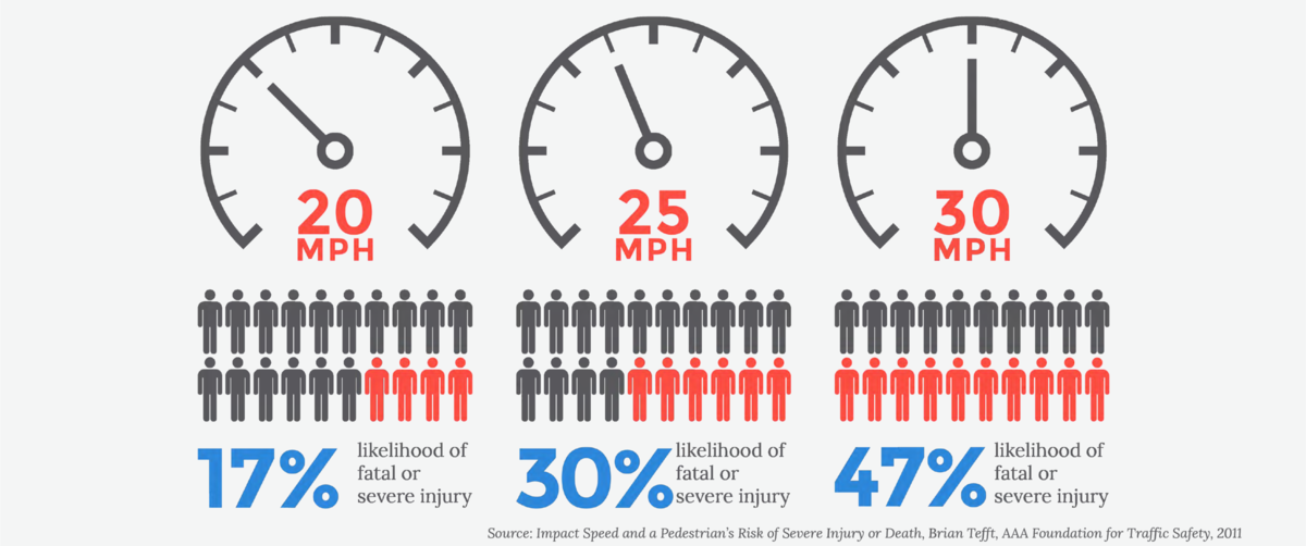
We began this project in spring 2019. Over the series of meetings we hosted in 2019 and 2020, residents of Mattapan and nearby neighborhoods shared a clear priority with us: a reconstruction project must address safety along the corridor. The community's goal corresponds with the data we have collected. Cummins Highway is among the most crash-prone corridors Citywide between January 2015 and December 2017. We know that drivers regularly exceed the speed limit on Cummins Highway.  Vehicle speed is directly related to the severity of a crash. At 40 mph, a pedestrian has an 80% likelihood of death.  Elders, youth, and people with disabilities are even more likely to be seriously hurt or killed in a car crash.

In addition, Cummins Highway was not in great shape. It needed to be repaved and to have a modern street lighting system. Sidewalks were in often in poor condition, and curb ramps were not accessible. In the one-mile stretch of Cummins Highway in Mattapan, there were only 21 trees.

Project goals

Accessible

New, smooth sidewalks and curb ramps mean everyone, including people with disabilities, will have an easier time walking and rolling on Cummins Highway. Rebuilt bus stops will have plenty of room for people in wheelchairs to wait, board, and get off the bus. Curbside parking will allow you to reach destinations on Cummins Highway.

SAFE

We designed Cummins Highway in response to clearly stated community priority for safety. One travel lane in each direction, with additional lanes for turning, will help slow speeds while maintaining traffic flow. Crosswalks will be safer: people have a shorter distance to walk and pedestrians will be more visible. Dedicated space for bicycling will create order and reduce conflicts. All of the street lights will be be new and provide better visibility in the roadway and on the sidewalks.

GREEN

We will plant over a hundred new street trees and maintain most of our existing, healthy trees. We're also adding "green infrastructure" to manage water when it rains. All of these plantings will help to reduce the impacts of heat during the day and beautify the street for everyone.

Design Elements

View the Final Design plan 


You helped us shape the final design for Cummins Highway. We met with you in-person at a series of public meetings and neighborhood meetings in 2019 and 2020. We then hosted monthly conversations about different design topics. We also talked with you on the street and at the Farmers Market. We heard about your ideas, preferences, and questions. Each conversation informed how we shape the final design plans for Cummins Highway. 

Some of the elements you'll see in our final design include:

  • Accessible sidewalks and safer crosswalks
  • Rebuilt roadway and a new roundabout
  • Functional and attractive street lighting
  • Green stormwater infrastructure and street trees
  • Convenient, accessible bus stops
  • Separated bike lanes
  • On-street parking

Previous Meetings and Updates

Past meetings

We hosted regular community conversations to refine the design for Cummins Highway.

July 2021

On July 8, 2021, we hosted a virtual meeting to share information about the City's heat resilience study. We also discussed opportunities to address heat through the Cummins Highway Reconstruction project.

On July 21, 2021, we co-hosted a virtual meeting to discuss the ways transportation policies and design influence air quality. We noted potential design changes possible with the Cummins Highway reconstruction project.

August 2021

On August 17, 2021, we hosted a virtual conversation with the BPDA to discuss land-use planning. They talked about their work and how we collaborate. They also provided information about transportation planning that is part of PLAN: Mattapan.

September 2021

We hosted a meeting on September 21, 2021, to learn about the City's street lighting team. We discussed the type of street lights we plan to use when we rebuild Cummins Highway.

October 2021

We hosted a public meeting on Tuesday, October 5, 2021, to talk about public health and transportation. We were joined by Mary Bovenzi, Director of the Chronic Disease Prevention and Control Division at Boston Public Health Commission.

On October 19, 2021, Dave Queeley from Codman Square Neighborhood Development Corporation talked with us about green infrastructure. He talked about why green infrastructure is important and showed examples from the Codman Square area. He also shared information on the jobs training program he manages.

January 2022

On January 25, 2022, we talked about accessible bus stops. We discussed where bus stops would be placed on Cummins Highway once the street is reconstructed. We also talked about how we ensure every bus stop is accessible to people with physical disabilities. We gave an update about the potential for bus shelters and real-time arrival information.

February 2022

 On February 23, 2022, we talked about the Urban Forest Plan and street trees across the City. We discussed how we are designing Cummins Highway for new street trees and protecting existing trees in good health. You can explore information about existing trees on Cummins Highway.

March 2022

On March 29, 2022, we discussed how the City of Boston designs intersections across the City. Every intersection must serve different needs: people crossing on foot or in a wheelchair, drivers turning left or right, people continuing through the intersection, and cross-traffic, to name a few. We shared our initial design plans for intersections on Cummins Highway. We talked about some of the ways we are working to balance competing needs at intersections.

April 2022

At this public meeting, staff from the City's Age Strong Commission joined the Public Works Department to discuss the upcoming reconstruction of Cummins Highway. We learned about “Age-Friendly Boston” and discussed street design strategies that support people as they get older. We talked about specific aspects of the Cummins Highway reconstruction project that incorporate age-friendly street design.

May 2022

At our meeting on May 25, the Mayor's Commission for Persons with Disabilities talked about their work to create systemic access throughout the City of Boston. They discussed their policies, tools, and collaborations. We shared information about street design for people with disabilities.

June 2022

We co-hosted a meeting with City's Arts and Culture team on June 21, 2022. We discussed the process for public art in the City.

Cummins Highway was identified as a high-crash corridor based on the volume of injury-causing crashes that occurred in 2015, 2016, and 2017. It is among the most crash-prone corridors Citywide.

On Cummins Highway, drivers regularly reached 40 mph despite the 25 mph speed limit.

In October 2018, more than two-thirds of all drivers on Cummins Highway exceeded 35 MPH. This speeding was rampant all day: between 7 a.m. and 8 p.m., two in three drivers traveled at 30 MPH or faster. Speeding rates significantly increased in the evening and early morning hours.

Vehicle speed is directly related to the severity of a crash. At 40 mph, a pedestrian has an 80% likelihood of death. The likelihood of serious injury or death is nearly 50% when hit by a driver traveling 30 mph. Elders, youth, and people with disabilities are even more likely to be seriously hurt or killed in a car crash.

We have data on traffic speeds from:

  • October 2018 (pre-pandemic)
  • August, September, and December 2020, and
  • May, June, and September 2021.

You can read about how we collect data and what we found when we compared the data from 2018 to the data from 2020. You can also download spreadsheets of the original data files.

Speeding on Cummins: August 2018 through December 2020

Speed Data Spreadsheets

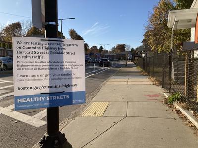
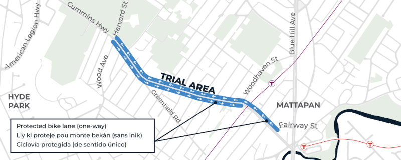
From summer 2020 to fall 2021, we tested a design concept on Cummins Highway between Wood Avenue and River Street.

The temporary redesign of Cummins Highway helped us understand what worked and what didn't.  After a full year of trying it out, we were able to evaluate the impacts of a two-lane design on traffic capacity and travel times. Traffic volumes remained consistent with pre-pandemic levels. However, drivers travelled at much safer speeds than they had before the temporary design was installed. 

A bar chart shows traffic volumes on Cummins Highway east of Savannah. Data were collected on two consecutive days in October 2018, August 2020, September 2020, December 2020, May 2021, June 2021, and September 2021. In October 2018, the daily volume of vehicles was 17778 and 18472. Over the following collection periods, it was usually between 15000 and 16000 each day.

A bar chart shows percentage of drivers traveling at or above 35 mph on Cummins Highway east of Savannah. Data were collected on two consecutive days in October 2018, August 2020, September 2020, December 2020, May 2021, June 2021, and September 2021. In October 2018, the percentage of drivers traveling at or above 35 mph was 34.6 on the first day and 39.2 on the second day. Once the trial was installed (before August 2020), the percentage of drivers traveling at those speeds decreased significantly.

However, a pilot project did not provide all of the safety benefits we need for this corridor. For example, sidewalk condition and accessibility for persons with disabilities could not be addressed, nor could concerns about poor lighting.

Further, we learned that we must remove the center-running median. The median hindered safe passing of stopped vehicles, such as trash trucks, and raised concerns about impact on response time for our EMS and fire departments.

We gathered a lot of information from residents about what worked and what didn’t during the temporary redesign. The final design will address concerns the community have voiced, including removing the median for safe passing.

In October 2020, the trial was extended to American Legion. In response to the feedback we received from the community, the orange barriers were replaced with flex-posts and pavement markings. These changes improved visibility for everyone. We will continue to monitor traffic, gather data, and collect feedback to evaluate this new phase. 


You can watch a virtual presentation of the Cummins Design Trial (Phase 2). You will be able to hear from Jeffrey Alexis as he provides a project summary.

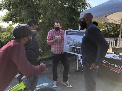
Two men hold a board while two others stand in front of them. They are talking about changes to Cummins Highway

Thank you to all who came to talk to us at the Mattapan Farmer's Market about the continuation of the Cummins Design Trial and the updates for phase 2.

We provided a handout that you can download about the project.

The first phase of the Cummins Design Trial was created to simulate the preferred design. Our goal was to improve safety along the corridor in response to COVID-19. The temporary trial extended from Fairway Street to the intersection of Wood Ave/Harvard Street. We used orange barriers to introduce protected bike lanes. We continued to maintain on-street parking and provide turn lanes at intersections. 

We monitored the traffic, gathered data, and collected feedback during the trial to evaluate the results. For more information, you can view the presentations below: 


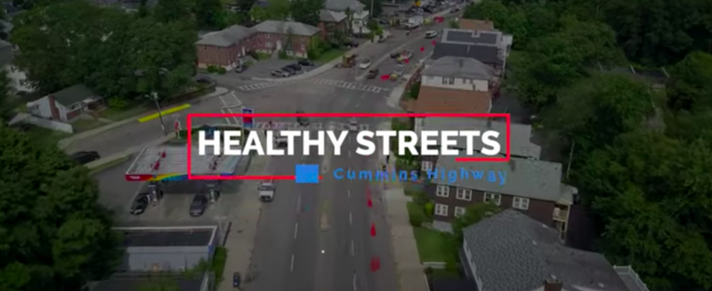
The first phase of the temporary design trial was part of Healthy Streets Boston. Click the image to watch a short-explainer about the trial and how it happened.


Click the image to view a project update recorded on July 2020 about the first phase of the design trial.

We have been collecting feedback from residents. These comments influenced changes to the temporary redesign and will inform our final design plans. You can read what your neighbors have shared with us:

On Thursday, February 27, 2020, we held the third public meeting at Mattahunt Community Center. We continued the discussion of potential improvements for Cummins Highway. 

You can review and download the materials shared during the meeting.

On Tuesday, October 29, 2019, we held the second public meeting at Mattahunt Community Center. We continued the discussion of potential improvements for Cummins Highway. 

You can review and download the materials shared during the meeting.

On Thursday, April 11, 2019, we held the first public meeting at Mattahunt Community Center. We discussed potential improvements for Cummins Highway. 

You can review and download the materials shared during the meeting.

PLAN: Mattapan

Contact: Planning

On October 3, 2022, the planning team released its Draft of PLAN: Mattapan for public review and feedback. You can access a PDF version of the Draft of PLAN: Mattapan in EnglishHaitian Creole, and Spanish. 

The Boston Planning & Development Agency (BPDA) works with people and communities across all neighborhoods of Boston to plan and build the future of the City. The planning department specifically works with the community to create long-term visions for places. PLAN: Mattapan is a neighborhood-wide planning initiative. The plan will strengthen the existing culture and stability of the community by:

  • supporting affordable housing
  • creating opportunities for businesses to thrive, and
  • enhancing connections to improve the neighborhood's experience accessing jobs and spaces where people gather.

PLAN: Mattapan has goals for housing, culture, environment, businesses, and mobility. Drawing from community members' comments and from Go Boston 2030, the planning team is working to increase access to high-quality travel options for Mattapan residents. The goals is for residents to safely and reliably connect to destinations within Mattapan and the rest of the City.

They worked with the community to identify "nodes," or places where commercial, retail, and residential uses are located. Nodes provide opportunities for people to gather and create a destination for the neighborhood. PLAN: Mattapan will identify corridors, routes, and other projects to improve access to these nodes — by bus, train, walking, biking, or driving.

The Cummins Highway Redesign is one opportunity to implement the values of PLAN: Mattapan, as communicated by residents and the goals of previous planning efforts.

On August 17, 2021, we hosted a virtual conversation with the BPDA. They talked about their work and how we collaborate. They also provided information about transportation planning that is part of PLAN: Mattapan.

Watch the meeting (English)

Download the presentation (English)

Download the Presentation (Haitian Creole)

Download the Presentation (Spanish)

Last updated:

National Consumer Protection Week Info Session

The Mayor's Office of Consumer Affairs and Licensing will host four informational sessions in celebration of National Consumer Protection Week. 

March 5, 2025
2025-03-05T11:00:00 - 2025-03-05T14:00:00

Consumer advocates will be available to answer questions and provide insights on various consumer topics, including shopping rights, tenant rights, credit, car purchases, scams, identity theft, home improvement contracts, and more.

March 5, 2025
2025-03-05T11:00:00 - 2025-03-05T14:00:00
Last updated:

City Hall On The Go: Mattapan

Join us on March 25, 2025, for a scheduled stop inside the BCYF Mildred Avenue at 5 Mildred Avenue, from 10:00 - 11:30 a.m.

March 25, 2025
  • 10:00am - 11:30am
  • BCYF Mildred Avenue
    5 Mildred Avenue
    Boston, MA 02126
  • Contact:
    Office Civic Organizing
  • Price:
    FREE
  • Neighborhood:
    Mattapan
  • Event Type:
  • Posted:
2025-03-25T10:00:59 - 2025-03-25T11:30:59

Our vibrant City Hall On The Go truck has a scheduled stop near your neighborhood, bringing essential municipal services right to you.

Please note: We do not accept cash payments on the truck.

March 25, 2025
  • 10:00am - 11:30am
  • BCYF Mildred Avenue
    5 Mildred Avenue
    Boston, MA 02126
  • Contact:
    Office Civic Organizing
  • Price:
    FREE
  • Neighborhood:
    Mattapan
  • Event Type:
  • Posted:
2025-03-25T10:00:59 - 2025-03-25T11:30:59

CITY HALL ON THE GO SERVICES

  • Absentee ballot request
  • Affidavit resident sticker
  • Appeal parking ticket
  • Basic Inspectional Services
  • Business Certificate (Check or Money Order Only) 
  • Census registration
  • File housing discrimination claim
  • File domestic partnership
  • Handicap parking
  • Medicaid and health insurance applications
  • Pay delinquent excise
  • Pay excise tax
  • Pay parking ticket
  • Pay real estate tax
  • Referrals for ASAP services
  • Register dog license
  • Register to vote
  • Request birth certificate

  • Request death certificate

  • Request marriage certificate

  • Resident parking sticker

  • SNAP applications

  • Farmers market coupons (Seasonal)

  • Income Eligible Reduced Fare T Program

  • Yard Waste Stickers 

Last updated:

City Hall On The Go: Mattapan

Join us on March 4, 2025, for a scheduled stop inside the Mattapan Branch of the Boston Public Library at 1575 Blue Hill Avenue, from 12:30 - 2pm.

March 4, 2025
  • 12:30pm - 2:00pm
  • Mattapan Branch of the Boston Public Library
    1575 Blue Hill Avenue
    Boston, MA 02126
  • Contact:
    Office Civic Organizing
  • Price:
    FREE
  • Neighborhood:
    Mattapan
  • Event Type:
  • Posted:
2025-03-04T12:30:59 - 2025-03-04T14:00:59

Our vibrant City Hall On The Go truck has a scheduled stop near your neighborhood, bringing essential municipal services right to you.

Please note: We do not accept cash payments on the truck.

March 4, 2025
  • 12:30pm - 2:00pm
  • Mattapan Branch of the Boston Public Library
    1575 Blue Hill Avenue
    Boston, MA 02126
  • Contact:
    Office Civic Organizing
  • Price:
    FREE
  • Neighborhood:
    Mattapan
  • Event Type:
  • Posted:
2025-03-04T12:30:59 - 2025-03-04T14:00:59

CITY HALL ON THE GO SERVICES

  • Absentee ballot request
  • Affidavit resident sticker
  • Appeal parking ticket
  • Basic Inspectional Services
  • Business Certificate (Check or Money Order Only) 
  • Census registration
  • File housing discrimination claim
  • File domestic partnership
  • Handicap parking
  • Medicaid and health insurance applications
  • Pay delinquent excise
  • Pay excise tax
  • Pay parking ticket
  • Pay real estate tax
  • Referrals for ASAP services
  • Register dog license
  • Register to vote
  • Request birth certificate

  • Request death certificate

  • Request marriage certificate

  • Resident parking sticker

  • SNAP applications

  • Farmers market coupons (Seasonal)

  • Income Eligible Reduced Fare T Program

  • Yard Waste Stickers 

Subscribe to Mattapan
Back to top