Planning for Future Parks
Planning for Future Parks identifies areas for park expansion. We're establishing a clear decision-making process for protecting or acquiring new parkland.
Our goal is to enhance and enlarge Boston's network of resilient community parks.
About
Our plans
Neighborhoods continue to develop and grow in density. The City wants to provide access to high quality parks throughout Boston that matches that growth. However, Boston had not had a broad, landscape-scale vision for parkland since Frederick Law Olmsted. The City aims to lay out a new vision that recognizes a fundamentally different landscape in terms of:
- culture
- environmental justice
- climate change, and
- development pressure.
Expanding the park system will rely on acquisition or protection by Parks and Recreation as well as other departments, state agencies, nonprofits, private landowners, and more.
A STRONG PUBLIC PARK SYSTEM RELIES ON:
Renovating our existing park system to better serve existing and new needs
Acquiring or protecting new parklands and natural areas to:
- fill in gaps where there are no such spaces, or
- enhance existing spaces where there is growing population pressure
Increased funding for high-quality park maintenance to match growing maintenance responsibilities
LANDS OF INTEREST
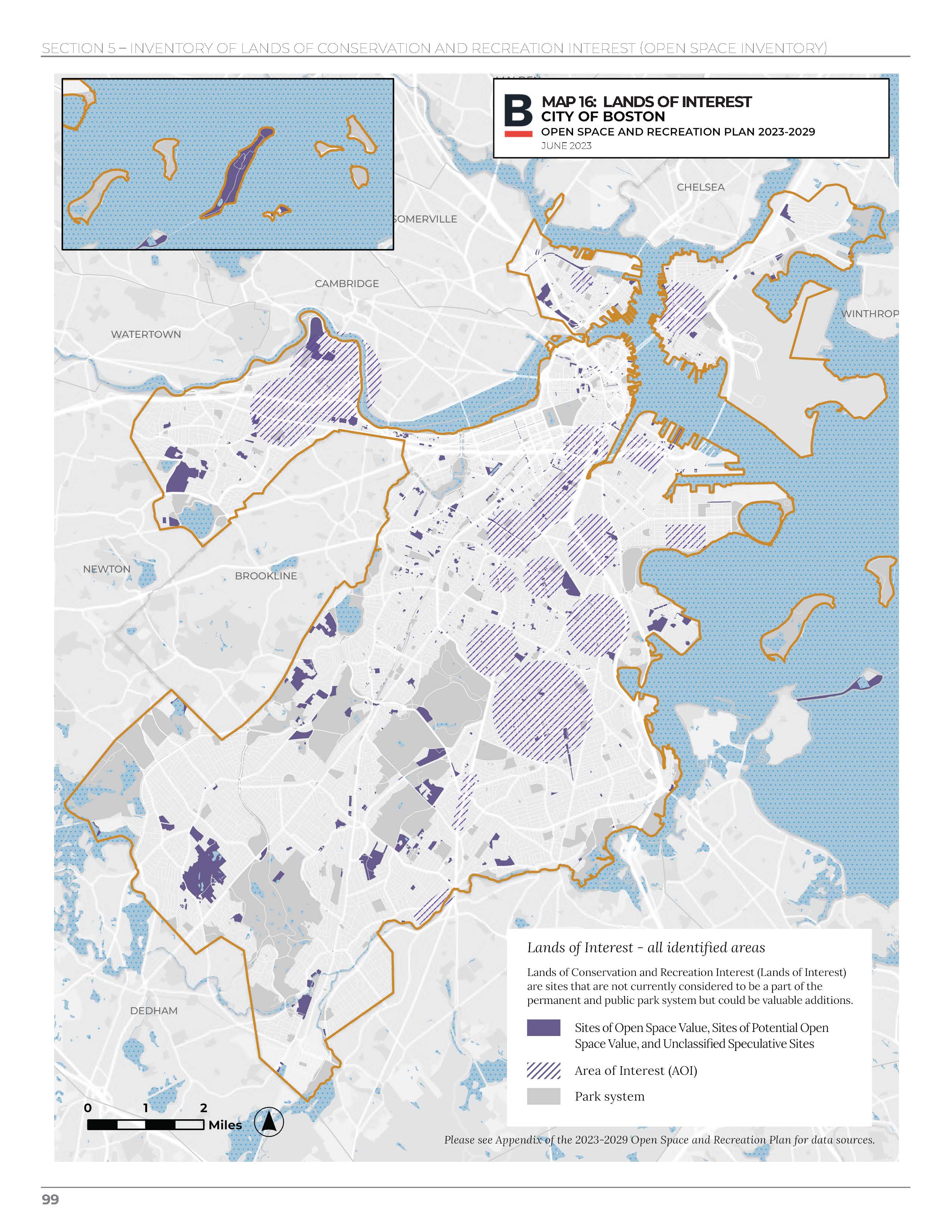
Check out the first publication of sites prioritized for park system expansion. The Lands of Conservation and Recreation Interest map and tables as published in Section 7 of the 2023-2029 Open Space and Recreation Plan. This is an ongoing process and the list of sites will be updated at intervals.
HOW LOCATIONS ARE IDENTIFIED
Sites are identified through a blend of geospatial modeling, survey responses, and institutional knowledge.

1. Neighborhood Modeling
Data on open space access, demographics, flooding, and heat were mapped across Boston. A score was assigned to each parcel indicating lower need or higher need. Interested in the details of the geospatial model? Click the link below to view both the maps and metadata.

2. Survey Results
Explore the results of the 2020 survey and see where more than 1,200 respondents placed pins where they thought open space should be created or protected. The survey will be reopening soon so that we can continue to receive location suggestions.

3. Institutional Knowledge
Institutional knowledge includes past community interests, historical efforts, ongoing work, and policies. The Open Space and Recreation Plan provides a comprehensive overview of Boston's park system as well as a Seven-Year Action Plan (Section 9 of the plan) that will guide the City’s parks-related work heading towards 2030.
Suggest a location
Suggest a locationOpen Space Acquisition Program
About the program
Expanding the park system requires financial resources and many partners. For its part, the Parks Department has established the Open Space Acquisition Program to purchase land for use as parkland. Initial funding comes from the Community Preservation Act.
Sites may be:
- donated to the Boston Parks and Recreation Department
- purchased from a property owner, or
- transferred to Boston Parks from another City department.
Learn more about the program or submit background information on a specific site you think should be considered for the program:
What can I do?
- Pin a location for consideration or submit detailed information on a particular site you'd like to see acquired or protected.
- Check out the Office of Housing's Grassroots and Open Space development program.
- Participate in the budgeting process. The annual budgeting process is where funding for the fiscal year is set. The fiscal year begins on July 1 and public hearings typically happen around April-June. If you would like to learn more about the budget, visit How the Budget Works.
- Explore the Boston Planning and Development Agency's neighborhood planning initiatives.
- Reach out to a local community group or property owner to discuss establishing a park or ask how you might support an existing community-run park.
Common terms
ACQUISITION:
In this context, acquisition is used to describe either:
- the process of transferring ownership of a parcel to Parks and Recreation, and/or
- the process of creating open space on a parcel.
LAND TRUST:
Non-profit organizations that manage and/or own land. Land trusts often specialize in housing or parkland. Conservation land trusts sometimes own parks and community gardens or aid in land protection by holding conservation restrictions for the permanent protection of properties. Land trusts are a great resource for learning more about community-led park creation.
OPEN SPACE:
This term is used interchangeably with "parks". It can describe permanently protected and publicly accessible:
- urban wilds and conservation lands
- plazas
- places with sports and other recreational opportunities
- landscaped areas with seating
Vacant lots and buildings are not considered open space, nor are streets and sidewalks. For this planning effort, we want you to highlight important areas that should become open space.
PARCEL:
Parcel is a real estate term describing an area of land owned by someone. There's an invisible line that denotes ownership and tax liability. This term is used interchangeably with "property." Often, multiple parcels can make up a park. For instance, Franklin Park is made up of a group of parcels that function as one continuous park. Sometimes only a portion of a parcel is devoted to a park.
PROTECTION:
Protection is a legal method to constrain types of development on a parcel, regardless of ownership, that conflict with its use as an open space. There are varying degrees of protection that affect:
- how long protection is in place, and
- what can happen on the parcel, and where.
The Parks and Recreation Department advocates for permanently protected and publicly accessible parcels. We want the public to have access to open space forever.


